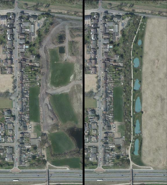
Green Zone Moat on old site Wisosplit
On the old Wisosplit site there will be a green strip that will serve as a connecting zone toward the outdoor area.
For this purpose, the municipality of Kerkrade has bought a piece of land of about 9000 square meters from Martel BV. This is a green strip about 40 meters wide between the gardens of the houses on the Grachterstraat and the company of Martel BV.
The green zone creates a natural buffer. At the moment, a new layout of the Wisosplit premises is being considered within the framework of the current zoning plan. All plans are worked out in consultation between the municipality of Kerkrade, the Province of Limburg and Martel BV.
Making the outdoor area more accessible
The green zone will take the form of a five-meter-high sound barrier and will serve as a connecting route to the outdoor area. On the side of the industrial area, there will be a path for cyclists and walkers at the bottom of the embankment. This path will connect to the Gaia bridge over the Buitenring. This embankment is expected to be ready before the summer.
Alderman Tim Weijers (Spatial Planning/Public Space):
"We like to make Kerkrade greener; this is a great example of that. The green zone on the Gracht provides a natural buffer between the homes and the business park and also serves as a connecting zone with a good walking and cycling connection to the outdoor area."
Connection zone between natural areas
The green zone will also form a connection between the nature of the Crombacherbeek valley and the green area along the tracks of the Miljoenenlijn. When designing the zone, various animal species such as various reptiles and amphibians as well as the badger will be taken into account. Rainwater runoff from the possible new business park will also be collected in the green zone. Between the green zone and the business park there will be a fence to prevent animals from entering the business park.
Click to enlarge the photo:
