From vision to action perspective

The stories and ambitions of the Environmental Vision are clear, but to make the vision easier to implement, we are translating it into a strategy in which areas are further defined. From the main functions as we currently know them in the temporary environmental plan (residential area, city center, working area, rural area), to a richer palette of area characteristics, each of which requires a different approach, different measures, or different programs. In this way, the Environmental Vision is building a new environmental policy structure that can be further developed with new measures linked to specific areas within the municipality.
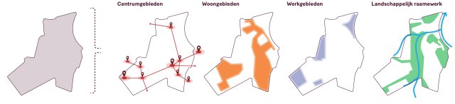
For each area, we have defined the characteristics we find there and how we want to deal with these places in the city. Where necessary, policy measures have been linked to areas or area characteristics. There is also a description of how new initiatives within these areas are dealt with or what requirements they must meet. The texts are accompanied by maps that clearly show which places are meant and how they are delimited.
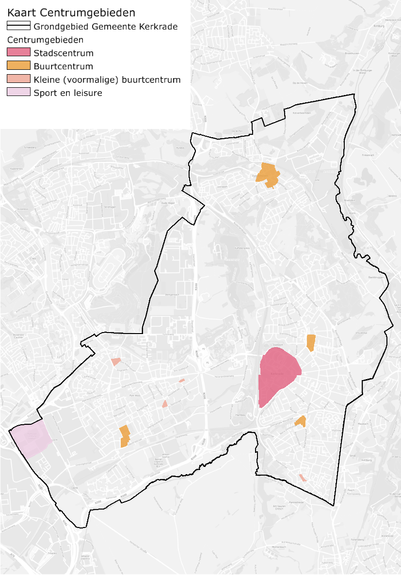
Central areas
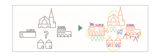
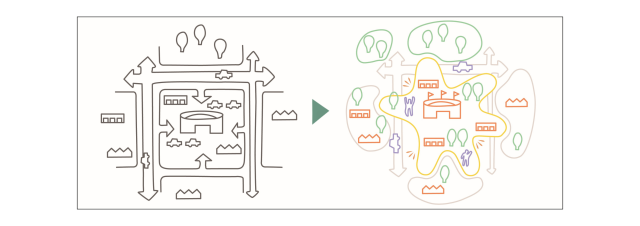
The multi-centered nature (many neighborhoods) of the municipality offers an opportunity to maintain the level of daily amenities in complete neighborhood hubs within walking distance of every home. Hubs where, in addition to a few shops, there is also room for amenities, community space, a mobility hub, or meeting space. That is why efforts are being made to intensify all existing centers.
The multi-centered nature of Kerkrade is one of its qualities that should be cherished. A recognizable community center with its own facilities provides identity and a sense of community. This is certainly true here in Kerkrade, because the community centers often also have cultural-historical elements that convey stories and give them their own character. However, it is necessary to view the definition of a community center as something more than just retail, because this is too limited an offering for the liveliness we have in mind and defines community from a commercial perspective. We prefer to speak of a community hub, a place where people, employment, facilities, shops, and landscape intersect. A high-quality environment that is pleasant to spend time in and a logical place to meet. We will also continue to focus on strengthening the entrances to the center areas.
Currently, Kerkrade has a good level of amenities, and we would like to keep it that way. There is a difference in scale between the neighborhood hubs, which also provides guidance when making spatial choices. The Environmental Vision therefore places a slightly different emphasis on the various centers than is laid down in the current Structural Vision for the Spatial Economy of South Limburg (SVREZL). In this way, we also want to pursue the preservation and improvement of the quality of life in the neighborhoods.
City center
The current city center serves as a community center for the surrounding residential areas, but also offers additional functions in the areas of culture (Rodahal, HUB, library, and theater), education (Het Martin Buber, music school), sports (VIE, sports hall, and indoor swimming pool), public transportation (bus and train station), healthcare institutions, retail, and hospitality. In the various neighborhood centers, but especially around the city center, there is also room for employment in SMEs, services, and (government) healthcare facilities. This is a major asset that contributes to the dynamic character of the center, which is why employment is being maintained and strengthened. However, there are still challenges and opportunities in the areas of housing, connections to the bus and train station, and greening. There is also currently no supermarket or neighborhood store in the city center, a facility that would be appropriate given its role as a neighborhood hub. In addition, the core shopping area of the city center is becoming increasingly compact in order to combat vacancy. Shopping streets such as Einderstraat, Marktstraat, and Hoofdstraat will be partially converted into residential streets by 2030.
Community centers
The biggest challenge at the moment lies in neighborhood centers such as Carboonplein, Hertogenlaan, Maria Gorettiplein, and Eygelshoven. Maintaining facilities is a major challenge in the run-up to 2050. Another challenge is to return parking lots to the community (where possible) by working on mobility hubs elsewhere and designing public spaces as places to meet and play. A good example of this is the square around the Socio Project in Eygelshoven, which is used as markt on Saturdays and only as a parking lot the rest of the week. These community centers are often located close to a school and healthcare facility. Linking these to the shopping area and finding space for new construction and greening creates more activity and makes it more logical to refer to it as a hub. It should be noted that there must be sufficient parking space at a supermarket.
- Map architectural qualities to neighborhood centers and historic streets. It does not need to be given heritage status, but efforts should be made to ensure that quality and special character are not lost. In addition, new layers of history can also be added to the heritage. Just as churches have done in the past, schools or community centers with a carefully considered architectural design can change the face of an entire neighborhood. Developing safe and healthy school environments.
- Climate adaptation measures for the most vulnerable functions to combat heat stress (Health, seniors, schools, childcare, playgrounds, sports complexes, social facilities, train stations, and bus stops) are based on the heat menu with three pillars: health/behavior (individual), building (climate-adaptive, nature-inclusive construction), and area (removing stone and greening the city). The latter measure in particular also has a positive effect on water management, because water can seep into the ground and is retained in the area for longer.
- The world of the Kerkrade resident extends beyond the national border. Connections to Herzogenrath, for example, by bicycle and train must also be of high quality so that facilities can be shared.
Small (former) community centers
There are also a few smaller areas where there is a cluster, such as Piusplein (Terwinselen), Dr Ackensplein (Bleijerheide), and the area around Heiveldstraat and Kapelweg (Kaalheide), or small meeting places. At Piusplein, the focus is on maintaining the facilities for the Terwinselen residential neighborhood. At the other locations, it is not necessary to add facilities, but it is important to continue to focus on creating attractive, green spaces that also cater to other generations.
Sports and leisure
Rodaboulevard. Rodaboulevard is a special location between a working area and a central area. On the one hand, it is an area focused on leisure and, on the other hand, on large-scale retail. It is a successful, frequently visited location that attracts visitors from across the Euregio. There is much to be gained in terms of image. By focusing even more strongly on the characteristics of sports and leisure, we want to bring about change in this area together with the landowners. We are striving for space for outdoor sports, more greenery, and good cycling facilities on Rodaboulevard with a good and safe connection to the adjacent residential areas in Kerkrade (Kerkrade-West) and Heerlen (Heerlerbaan).
Preconditions for new initiatives
- The initiative shows respect for the iconic and/or cultural-historical elements present. Existing heritage values will be preserved, expanded, and strengthened.
- We are committed to preserving religious heritage. Vacant churches are being given a new function. Churches will only be demolished if there is no other option. The recently drawn up Church Vision provides guidance for the future of all churches in the municipality of Kerkrade.
- Squares should be used for multiple purposes; currently, parking is their primary function. There should be space for sports, exercise, play, and socializing.
- New initiatives for (small-scale) recreational accommodation should be located close to recreational and tourist facilities or in iconic buildings of cultural and historical value. The focus is on high-quality recreational accommodation.
- New (social) facilities are preferably located in central areas;
- Schools, playgrounds, and childcare facilities will not be built on busy thoroughfares. In addition to this precondition, there must be at least 30% green space in the school environment, and parking must be located at a distance. In addition, the public space around and leading to the schools will be designed to encourage physical activity, and children will be encouraged as much as possible to walk or cycle to school. The presence of unhealthy facilities (such as snack bars and coffee shops) also plays a role in the choice of location, and we want to ensure smoke-free zones.
- Parking standards in city centers, close to amenities and public transport (train and bus stations) should be reduced in the long term due to limited space. We want more space for slow traffic, meeting places, and greenery.
- New developments should contribute to an attractive, green, and climate-adaptive living environment.
- Focus on retaining and, where possible, processing rainwater on your own property. For a climate-proof design, the standard rainfall is 80 mm in two hours (with availability/drainage within 24 to 72 hours).
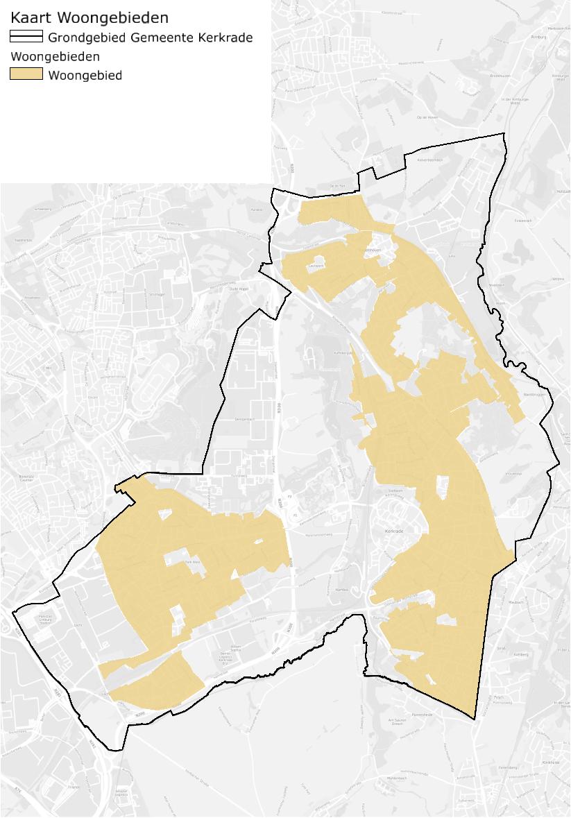
Residential areas
Housing construction is an important strategic element in urban planning. As soon as homes are developed, we invest in locations. We prefer to see those investments land where we have challenges, so that opportunities for collaboration arise. Housing construction as a lever for the neighborhood. That is why we prefer redevelopment and the integration of new homes into existing neighborhoods over new construction in rural areas.
Housing construction is not just about growing the municipality. Homes make the city, because they house the (new) residents who together form the community. But also because spatial investment can help in working toward ambitions and goals. Housing construction as a lever to also green public spaces (counteracting heat stress), make them more climate-proof (reducing flooding), create space for energy transition, add facilities, create meeting spaces, or bring diversity to housing (housing career).
Kerkrade currently has a high percentage of social housing, accounting for over 46% of the total number of homes. Whereas other municipalities are striving to achieve a 30% social housing ratio, Kerkrade faces the opposite challenge: reducing the proportion of social housing in the municipality. The focus in the future will therefore be on housing construction in other, more expensive segments, so that there is more diversity in the housing stock. This is also related to the growing economy in Kerkrade, where the number of jobs has risen in recent years. For example, 738 jobs will be added in 2023. The public housing program will determine which homes can be built based on demand. At least 1,300 new homes will be built in Kerkrade by 2030. It is necessary to take into account the transformation to lifetime homes and the accessibility of healthcare facilities. This is particularly important in the next 10-15 years, when the peak of the aging population is approaching. The construction of lifetime homes will stimulate movement in the housing market and free up existing homes for first-time buyers and families.
In recent years, large-scale restructuring has taken place in the residential neighborhoods of Heilust and Bleijerheide (SUPERLOCAL). Over the next ten years, the restructuring of Rolduckerveld and part of Bleijerheide will continue. In the longer term, the locations Mucherveld (southern part of the center) and Eygelshoven will also be included. Vital and resilient residential neighborhoods with self-reliant residents form the basis. Sustainable and circular design, demolition, and construction are important factors in future plans.
The population decline has slowed down and even stabilized in recent years. This has led to increased demand for new housing. The 'New Narrative' of the Parkstad urban region: 'Parkstad Limburg offers space!' capitalises on this. Kerkrade is following this development. With the construction of new homes, restructuring is creating an opportunity to focus this investment on areas that will benefit from it. The right home in the right place is an important principle in this regard. Preferably, space for new construction will be sought in the first five areas listed below. There is no strict order of preference for the first five areas.
Neighborhood hubs
There is still room for housing development in the heart of these neighborhoods. We see particular opportunities for housing for the elderly, enabling them to live close to amenities and social activities. This requires the development of a safe traffic environment, accessible public spaces, and good quality of life.
Station locations
Eygelshoven Markt Kerkrade Centrum stations offer opportunities for housing development. In the Euregional context, a study (Transregioexpress) is being conducted into the development opportunities of the station areas located along the route of the Drielanden train between Aachen, South Limburg, and Liège. For the municipality of Kerkrade, this development is particularly Markt for the Kerkrade Centrum and Eygelshoven Markt stations.
Historical ribbons
Utilize existing architectural gems and add new gems on vacant lots to bring the historical quality of this place back to life. A prerequisite for this is a change in the traffic structure (more greenery, more space for bicycle traffic, less noise and insecurity). This will also make the ribbon developments an attractive place to live again. The further conversion of former commercial buildings, such as shops, cafes, and offices into homes
is part of this strategy. After all, we prefer to see amenities clustered in neighborhood centers.
Within existing residential neighborhoods
There are various places in the municipality where there is untapped potential or where space is used extensively.
For example, there are various large parking lots, empty courtyards, or small patches of residual green space that could potentially be redesigned. Where there is space on the edges of existing residential neighborhoods, a 'street' could be developed, with attractive homes for families. The plan for Kaffebergsweg is an example of this.
Areas of expertise
Some areas in and on the outskirts of the city may be prone to some discoloration due to their proximity to residential areas, train stations, and amenities. Examples include Sportstraat (near the Kaalheide sports park) and the slaughterhouse site on Hammolenweg.
Explanation locations
In addition to the five areas mentioned above, Requirements explanatory location can be created within or on the edge of the landscape framework under Requirements . We also see opportunities for building homes at such locations. These locations are particularly suitable for higher-end housing types. Within urban areas, there is often less space for such homes (due to limited ownership, among other things), because the low density does not match the ambitions of more urban housing locations (diversity of homes, support for facilities, other segments, and high-quality public space).
Preconditions for new initiatives
- As a rule of thumb, new developments should not increase the paved surface area compared to the current situation. In the case of large-scale inner-city redevelopment, the aim is to achieve a 10% reduction in paved or built-up surface area. For the municipality of Kerkrade as a whole, the aim is to achieve a 20% reduction in paved surface area by 2050 compared to 2025.
- Focus on retaining and, where possible, processing rainwater on your own property, especially on higher plateaus. For a climate-proof design, the standard rainfall is 80 mm in two hours (with availability/drainage within 24 to 72 hours). In the future, the standard rainfall may change as a result of increasingly extreme weather, which means we will have to take extra space requirements into account. The horizon for the Environmental Vision is 2050. When it comes to flooding, we will have to look further ahead (towards 2100) for new (construction) plans in order to create a water-robust and climate-proof living environment.
- New housing development plans must take into account the availability of grid connections and drinking water supplies, which are strict preconditions for new housing development plans. Obstacles related to grid congestion are already noticeable, and after 2030 there is also a risk of drinking water shortages.
- New construction should contribute to a balanced housing stock in Kerkrade: the right home in the right place, quality in housing typology, price, and target group. Currently, Kerkrade already has a high percentage of social housing (46%). The focus will therefore be on housing construction in other segments in order to develop more diversity in the housing stock. A public housing program will need to further elaborate on how many and what types of homes can be built in which locations. It will also be necessary to take into account the transformation to lifetime homes and the accessibility of healthcare facilities.
- The municipality is committed to providing adequate housing for various target groups.
- The pursuit of equal opportunities and a healthy generation in 2040 requires unequal investment and a focus on areas where health, resilience, and quality of life are lowest, such as parts of Kerkrade-West and -Oost. In such places, we are committed to a coherent area-based approach (cross-domain and in collaboration with partners). Approach or transformation of the historic ribbon developments, combating structural vacancy, management of the many rear areas in the urban area, and other redesign of public space.
- Vacant or empty commercial properties located in residential areas should be given a new function, preferably residential or green space. The construction of new garages and storage facilities is not desirable.
- The initiative contributes to the creation of a mixed neighborhood where different types of housing and target groups live together. A healthy mix of demand and supply is essential in this regard.
- New homes must be appropriate to their surroundings in terms of mass, height, and spatial quality. We are committed to improving the quality and livability of the existing living environment.
- A contribution is made to a balanced housing stock that responds to current and future needs in terms of type and price range.
- Due to increasing space scarcity, we are focusing on multiple use of space and continuing to pay attention to high-rise and multi-story buildings (at least three stories). In addition, there must be space for indoor storage rooms, bicycle parking facilities, parking facilities, and waste disposal facilities.
- New homes comply with current sustainability requirements and are built to be climate-proof (also taking into account overheating indoors).
- Sports fields (belonging to clubs), schoolyards, and playgrounds are open to the public as much as possible, so that exercise can also be facilitated outside of opening hours.
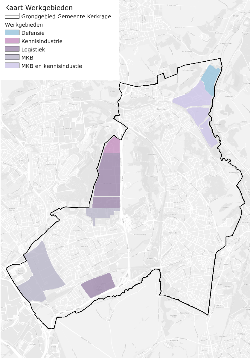
Areas of expertise
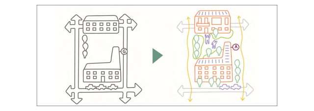
We see different areas of activity in Kerkrade, each with its own specific qualities. In some cases, this is an excellent Euregional connection. In others, it is the proximity of the city, the train, and nature. That is why we are committed to diversifying the business parks, so that the economic profile of the municipality becomes broader.
Because many work areas in Kerkrade are designed as industrial estates, there is a great deal of uniformity in the working environment. From a spatial design perspective, an industrial estate is hardly considered part of the city, but only as commercially exploitable space, which means that more 'urban' issues such as accessibility, greening, and connectivity are not part of the design. A strong work-life identity for Kerkrade makes use of diverse working environments. Their location on networks and in the urban area offers opportunities for more specific characterization and design. It should be noted that just outside the municipality, in the municipality of Heerlen, there are large business parks for logistics and MedTech (Trilandis, Beitel, Avantis). In Kerkrade, a characterization of areas that ties in with this is being sought.
Space for logistics
Willem Sophia and Dentgenbach Zuid. These areas are somewhat isolated from the urban area by green buffers and are easily accessible for logistics traffic, close to the Buitenring Parkstad (N300). In these areas, attention is paid to climate adaptation in order to ensure a healthy working environment for employees.
Knowledge industry
Dentgenbach North and part of Julia. These are landscaped campuses where the countryside comes in, so that recreational routes from the city to the countryside can be created through these areas. The areas are well connected to a nearby train station and there is space for a meeting place for employees. For the Julia business park, this also means a reduction in the environmental category. This area is difficult to access for logistics transport and is located next to the nature reserve (Wormdal). The current use, which is now heavy industry, is not appropriate for this location.
Local SMEs
Spekholzerheide and Beitel/Locht. Areas with a mix of residential and commercial properties in some locations. Attention is being paid to the high-quality design of public spaces, including with regard to traffic volume and road safety. These locations must continue to offer space for the SME sector, and it is preferable to create smaller commercial plots.
SMEs and knowledge industry
The Julliaterrein site is suitable for a combination of local SMEs and knowledge-based industries. Logistics is less desirable at this business park due to its relatively large distance from regional connections (N300).
Defense
The US military base in Eygelshoven also provides employment opportunities. Given the geopolitical situation, this offers opportunities for more employment. Looking ahead to 2050, there is still the ambition to return parts of these areas to the natural environment of the Wormdal.
Preconditions for new initiatives
- Implementing mobility transition in the work areas: the areas must be more accessible by bicycle and public transport.
- Climate adaptation and mobility are also taken into account in new business developments. In addition, more attention must be paid to the appearance and landscape integration of commercial buildings, which must be in keeping with the surroundings and the landscape.
- Focus on retaining and, where possible, processing rainwater on your own property. For a climate-proof design, the standard rainfall is 80 mm in two hours (with availability/drainage within 24 to 72 hours).
- In Kerkrade, industrial estates are the largest consumers of energy (36% of demand). Due to grid congestion, large initiatives will have to generate and store as much of their own energy as possible, at least in the near future. The question is whether this is feasible, as there are also challenges relating to noise and nitrogen.
, it remains mandatory for new buildings to use the roof surface for solar panels in combination with green roofs (to retain rainwater and limit heat stress). Cooperation can also be sought in this area to work towards collective energy hubs on the sites. At Dentgenbach, companies are starting a pilot project to coordinate generation and consumption (also known as an energy hub). If this proves successful, such an approach could also be adopted elsewhere. - The energy transition, including the development of large-scale energy storage systems (e.g., battery storage), is expected to take place in industrial areas. Space must be reserved for this purpose. We also take environmental safety into account. Consider the risk of fire and explosion hazards and the location of these systems in the vicinity of (highly) vulnerable functions, such as schools, care centers, and homes.
- The initiator of the initiative is aware of potential safety and environmental risks and is taking the necessary (mitigating) measures to address these. The theme of external safety will be further elaborated in the new environmental plan. The municipality is committed to lighter industry; growth in heavy industry is not desirable. At the same time, the (growing) number of employees in the industrial estates and the associated group risk must be taken into account. Safety must be guaranteed for employees.
- Towards 2050, further efforts will be made to focus on companies with a lower environmental category compared to 2025. New locations for heavy industry are not desirable.
- New small-scale businesses (with a potential impact on the living environment) should preferably be located in business parks rather than residential areas. However, there is room for service providers and SME entrepreneurship within city centers.
- Large-scale business activities (with a potential impact on the living environment) always take place on one of the business parks, in line with the profile of the business park.
- The initiative contributes to circularity by reducing waste streams or reusing residual flows in the municipality of Kerkrade and the Parkstad region.
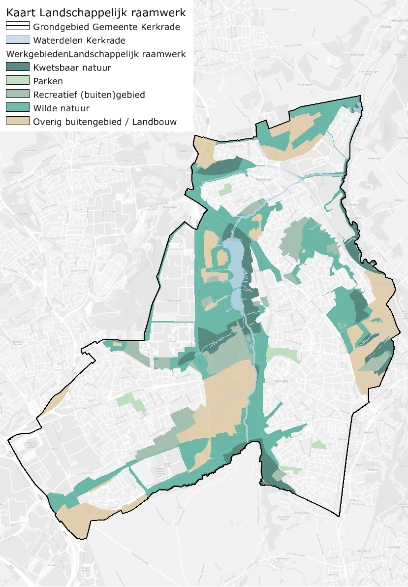
Landscape framework
The landscape in and around the city is of great value, both now and for the future. It provides residents with a green and healthy environment, attracts visitors to the city, and provides space for water and a greater variety of animals and plants (increasing biodiversity). That is why we are committed to protecting the countryside and its functions, as well as the green spaces in the city.
The landscape in and around Kerkrade is the municipality's most important asset. It ensures a high-quality, healthy living environment. By Dutch standards, it is a unique piece of nature and landscape. However, as described earlier, the rural area is still under pressure. The rural area needs to be demarcated, both in terms of areas that are entirely dedicated to nature and areas where other functions play a role. The existing policy will be continued. In principle, no red developments are possible in green areas. In addition, we assign protection status to areas, with the Dutch National Nature Network (NNN) taking the lead. The landscape framework is part of the green-blue network and an essential component of a water-robust and climate-proof city. Within the landscape framework, which is largely located in the outskirts, we distinguish the following sub-areas:
Vulnerable nature
There are a few places in Kerkrade where nature, with its specific plants and animal species, is so fragile and valuable that we do not make these areas accessible for recreational use. These are mainly parts of the Wormdal and smaller nature reserves with springs and seepage areas (such as the Vrouwezijp spring forest near Rolduc, springs near the reservoir, the Dentgenbacherbeek, Crombacherbeek, and parts of the Bleijerheiderbeek/Peschbeemden) scattered throughout the municipality. These areas are part of the Dutch Nature Network. These areas are part of the Dutch Nature Network and the Waterdelen in Kerkrade.
Wild nature
The north-south connections along the Wormdal and Anselderbeekdal valleys are part of the NNN and form an important link in the European ecological main structure. We cherish and strengthen these natural, wild areas so that they remain a robust structure. Within these areas, recreational use in the form of walking and cycling in various places is possible. The Green Lung (Anstel Valley), Carisborg, Berenbos, Hambos, Peschbeemden, and the area near Rolduc Abbey form the feeding areas for these structures. These feeding areas are also found in other landscape types with a different protected status. It is important, especially for the NNN, to continue to view the various landscapes in context and to connect and strengthen them.
Recreational outdoor area
Holzkuil/Carisborg, Berenbos, Bergbos, and Schouffertsbos. These areas form an important link between the built-up area and the surrounding nature. They are crucial to ensuring a healthy living environment. There is room here for more uses, such as sports and games. These are also places where the nature reserve can extend further into the city. This creates a stronger connection with and appreciation of the beautiful landscape.
Other rural areas and agriculture
Agriculture will always remain an important part of rural areas. Preserving that agriculture goes hand in hand with strengthening the landscape and biodiversity. Kerkrade is not a large-scale agricultural municipality. We see that, in addition to their business interests, farmers also play an important role in maintaining our landscape. Think of the slopes, valleys, and open vistas that make Kerkrade so special and beautiful. On some steep slopes, land use will change to prevent erosion and flooding, allowing them to develop into valuable grasslands with landscape features. This strengthens nature and makes the countryside attractive to residents and recreational users.
The agricultural areas are located in the Anstel Valley, the Ham, the area north of Eygelshoven, near the hamlet of Baalsbruggen and Rolduc Abbey. The municipality aims to use its land strategically within the landscape framework (applying a more active land policy) to enable sustainable agriculture, focused on strengthening the landscape and improving biodiversity. Together with partners such as the Limburg Landscape Foundation, Rolduc, and farmers, we are looking at how we can intelligently combine agriculture, (cultural) landscape, and nature management.
Parks
In addition to rural green spaces, Kerkrade also has urban green spaces in the form of city parks. City parks are an important "stepping stone" for people to enjoy recreational activities in green spaces close to home. The parks are designed to be biodiverse and climate-proof. The parks also offer space for activities and festivities by making room for small-scale catering facilities, toilets, rest areas, and play and sports facilities.
Neighborhood greenery
Nature and greenery are not only found in designated areas such as parks or the countryside. In every neighborhood, small green elements contribute to the overall system. These small elements are not nec
ly connected to larger structures, but they do play an important role in ensuring a basic quality of nature throughout the municipality. Therefore, preference is given to planting native species.
Cultural-historical elements
We want to protect (better) the cultural-historical, archaeological, and small landscape elements that are present. In doing so, we look not only at the buildings, but also at sunken roads, church paths, hedges, ditches, thickets, religious heritage (chapels and wayside crosses), and stately tree-lined avenues.
Preconditions for new initiatives
- In built-up areas, space is being sought for the removal of (unnecessary) paved surfaces, with the aim of achieving a 20% reduction in paved surfaces by 2050.
- Apply the 3-30-300 rule as a guideline to all residential areas. In principle, every home should have a view of three mature trees, at least 30% tree canopy coverage, and a cool green space of at least 200 m² within a maximum distance of 300 meters from each home.
- The goal is to achieve 40% shade along important walking and cycling routes in the city.
- We want to preserve mature and valuable trees (avenues). Where tree structures play a role in heat mitigation measures, the trees are given the space to mature.
- New recreational cycling and walking routes connect the various green areas and promote an exercise-friendly environment.
- The initiative fits well into the landscape and enhances its existing qualities.
- The initiative opts for robust landscaping. Existing greenery will be preserved as much as possible, and the starting point is a minimum of 20% greenery in new (construction) plans.
- The chosen landscaping contributes to biodiversity thanks to a rich variety of native and climate-resistant plants that attract many species of animals.
- Water and soil are key factors in spatial development. There is sufficient space for water and greenery to combat heat stress, flooding, and drought.
- The outdoor space and buildings have a climate-proof design (light colors and natural materials) with sufficient space for retaining and processing rainwater on the property (standard rainfall of 80 mm in two hours, with availability/drainage within 24 to 72 hours).
- In new construction and renovation projects, we encourage the use of green roofs and facades for better insulation, water storage, and biodiversity.
- The initiative contributes to improvement and certainly does not lead to a deterioration in (ground) water quality.
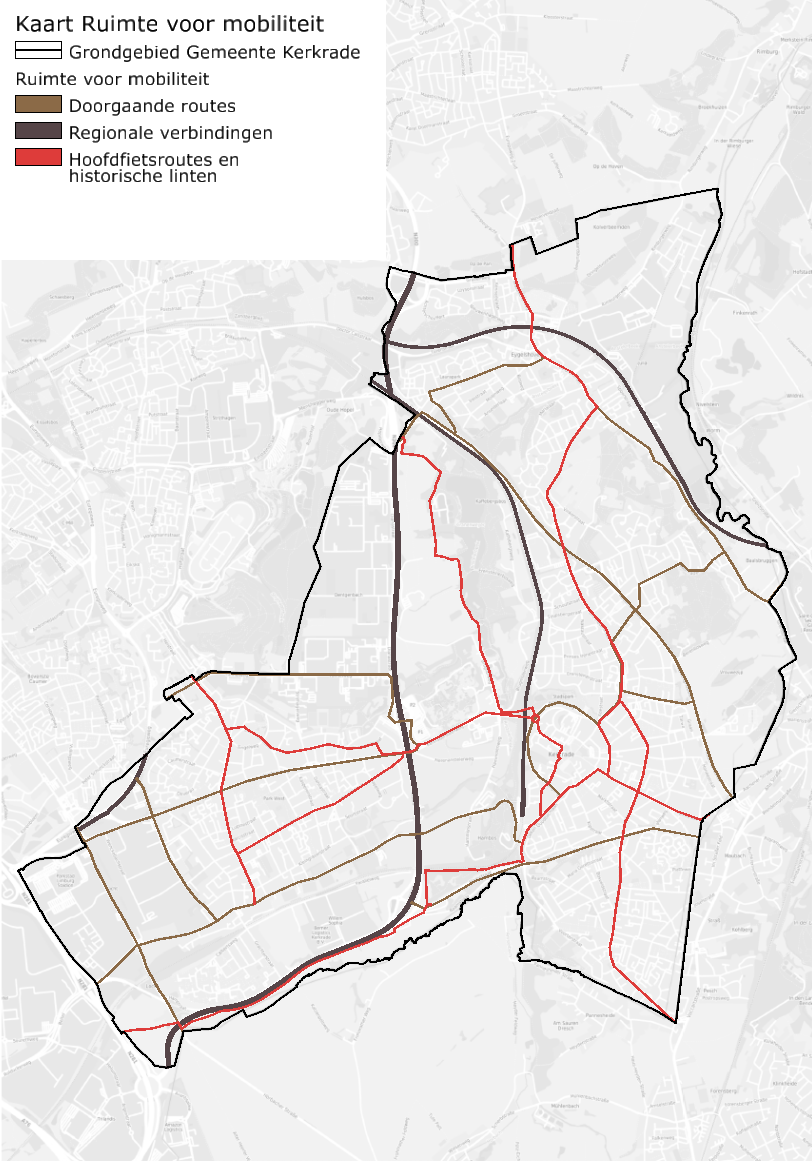
Space for mobility
Cars have become increasingly dominant in our streets. They are a convenient means of transport, but in urban areas they leave little room for greenery, social interaction, or other road users. That is why we are committed to offering alternatives to the car, including transforming a number of historic ribbon developments into walking and cycling streets. In this way, we are working towards creating space for mobility where the car has a place, but does not have to be used for every journey.
We are emerging from a long period in which the private car was at the top of the pyramid. The traffic system is often designed to guide cars through the city as quickly and smoothly as possible. With the increase in the number of cars, including parking spaces, it is becoming increasingly clear that this leads to undesirable situations in various places. It is dangerous for children to play outside, there is noise pollution and poor air quality, and there is little room for greening. That is why we are developing a traffic system with more hierarchy and clarity.
Regional connections
The Buitenring Parkstad (N300) is a specific road structure where other traffic has no place. The speed limit here is high (maximum 100 km/h) to speed up traffic flow.
Through routes
The main access roads to the outside remain important routes for motorized traffic. The speed limit here remains 50 to 80 km/h.
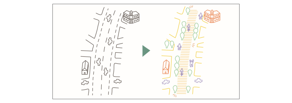
Main bicycle routes and historic ribbon roads
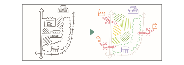
History is still palpable in some places in Kerkrade, perhaps most of all when you cross the city along the old ribbon roads. Different layers of time alternate continuously. Unique architecture, church buildings, and historic centers. Everywhere you look, there are little gems that contribute to the local identity. But these important arteries have become busy, unsafe, and unhealthy places due to increased traffic. This is also reflected in the increasing vacancy rate
. That is why we are shifting the focus here to the ribbon as a bicycle street where cars are guests. Local traffic is possible, but through traffic is not. The ribbon roads will offer more space for bicycles, pedestrians, and greenery. By 2050, the speed limit here will be 30 km/h. This transition will be initiated on the historic ribbon road Bleijerheiderstraat. Business activity and parking spaces attract unwanted traffic, so they are less suitable for the ribbon structure. The vacant rear areas offer space to relocate the current parking facilities (no addition of garage boxes) to the historic ribbon.
Residential neighborhoods
On smaller roads, the focus is on quality of life. We ensure low speeds and safe crossings.
- Maximum speed of 30 km/h on all non-through roads.
- Children aged 8 and above can cycle independently through the neighborhood to their important destinations (school, sports, etc.).
- Safe school environments.
Access roads to public transport hubs
Important public transport stations (bus and train) must be easily accessible for passengers. Connections for pedestrians, cyclists, and disabled travelers need attention in many places. Kerkrade currently has four train stations, but sees potential for an additional train station in Kerkrade-West in the future (also to improve quality of life).
Hiking area
Around community centers, we are focusing on creating a (larger) pedestrian area with space for meeting and playing. We are also focusing on creating connections with the adjacent green areas.
Preconditions for new initiatives
- Encouraging bicycle use. Among other things, by expanding the bicycle sharing program to other important destinations and by focusing on regional and cross-border connections. There are opportunities for a bicycle connection between Kerkrade-Noord and Landgraaf. New connections will also be realized that link up with the Parkstadroute. For example, a new bicycle path has been constructed between Chrevemont-Hopel (Roderlandbaan (N299)), and a bicycle bridge will be built at the Stationsstraat, Hamstraat, Voorterstraat, and Domaniale Mijnstraat roundabout.
- Safe cycling and walking program: investigating bottlenecks in order to create a network of cycle routes, wide sidewalks, and safe crossings.
- Evaluate and adjust established parking standards. Investigate which standards are appropriate for the next ten years. The closer to train and bus stations and community centers, the lower the parking standard.
- Vacant or empty rear areas adjacent to historic ribbon developments offer opportunities for new uses. The areas can be used for parking facilities, greening, or small-scale housing. Multifunctional use of space is encouraged.
- Public spaces are designed to be inclusive wherever possible, which means that everyone's needs are taken into account in the design of public spaces. Public spaces are accessible to parents with young children, elderly people, and people with disabilities. This includes wheelchair-friendly ramps, wide sidewalks without loose tiles or other obstacles, and crosswalks with sufficient time to cross. Kerkrade wants to be a city where everyone can participate and where no one is excluded.
- The initiative contributes to the mobility transition and thus encourages less car use and more walking, cycling, and public transport use.
- We remain committed to continuing the Heuvelland line from Kerkrade-Centrum train station to a new train station in Kerkrade-West.
Maps functions Kerkrade
Complete overview
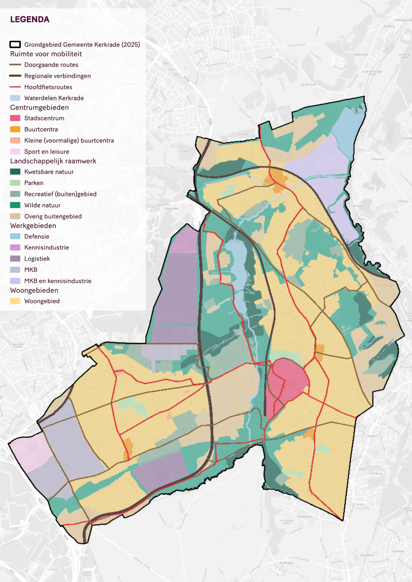
Central areas
Residential areas
Areas of expertise
Landscape framework
Space for mobility